Total, Shell Buy into MACH Data Set
BMT ARGOSS Ltd, the Met Office and Oceanweather Inc. have announced the launch of their joint Mid-Atlantic Current Hindcast (MACH) data set, resulting in two successful data sales to oil and gas majors, Shell International Petroleum Company Limited and Total S.A.
The Met Office is one of the leading organizations in data assimilation and large scale, complex ocean circulation modelling. The pioneering work of Oceanweather’s hindcast approach and derivation of optimal wind fields for ocean boundary forcing has been recognized internationally in both the scientific community and in applications for the offshore industry. This knowledge and expertise coupled with BMT ARGOSS’ extensive experience in applying and validating metocean data for commercial application is already recognized and highly valued by the oil and gas community.
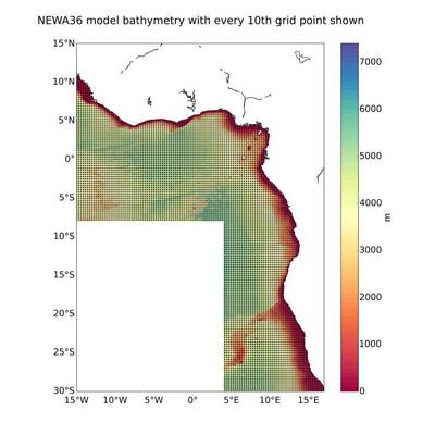
Using their combined knowledge, experience and computational resources, the MACH team have worked closely with oil and gas operators to provide a robust current data set over the West Africa region. Unlike other current data sets available, the MACH data set provides information on the long-term variability of currents over a 20-year period and has been validated against measured data throughout the region. The initial focus has been to provide a 20-year fine resolution data set for the West Africa oil and gas concession region.
Valérie Quiniou-Ramus, Head of TEC/GEO & Metocean Specialist at Total commented: “Total is interested in MACH to provide a comprehensive database, useful for developing design criteria for offshore structures, as well as for environmental impact assessment studies. As MACH has been developed in a collaborative way by pooling together Operators’ current measurements for better validation, and with the expertise of the Met Office and BMT ARGOSS, we trust that it will be a reliable tool.“
The MACH data set will be used to better understand the ocean conditions within a potential development site or to gain advanced knowledge of the conditions prior to exploration drilling. Vertical profiles of current speed and direction are critical inputs to riser engineering and deep-water developments offshore, whilst near-surface current spatial information may provide valuable input to oil spill contingency planning and support FPSO and vessel operations. With the reduction of costs being a prime driver in today’s environment, this data set will provide regional information that will help refine the design and increase the efficiency of the installation and operation of oil and gas producer’s assets offshore.
With this phase of the modelling complete, the team are now looking to expand the fine resolution modelling to other parts of the mid-Atlantic basin, including Brazil.
Robin Stephens from the MACH team commented: “The MACH data set for West Africa is now available commercially and we are hoping that access to this data set will allow closer engagement with oil and gas operators, contractors and engineering consultants to help them understand the conditions in one of the key hydrocarbon basins in the Mid-Atlantic region. We are looking forward to collaborating further with oil and gas operators to understand other regions, including Brazil. This collaborative approach to understanding industry requirements with joint resources and experience has been of great benefit to all parties and forms the basis for future projects.”


